
Search by Address (Enter E. for East and W. for West, ETC. )
Search by Subdivision and Lot
411 E. Olive Ave.
Thomas Wardall's Orange Grove Subdivision
This property has a long history of ownership which makes it difficult to say which person was the original landowner: Mission San Gabriel? Andreas de Duarte? J.D. Bicknell or Thomas Wardall? For information on Mission San Gabriel and Adreas de Duarte, see the entry for Rancho Azusa de Duarte in the Subdivision Category. For information on John D. Bicknell, see Addition No 2 to the Monrovia Tract. Because the last subdivision of the property was by Thomas Wardall, I am going to name him as the original landowner


This picture shows a glimpse of the two-storey rooming house on Lot 21. This picture dates from 1915-1920. The land to the east up to Ivy Avenue is still vacant. The house to the east of the boarding house won't be built until 1922.

This picture dates from the 1960s and is the reverse of the picture before it. The houses on Lots 21-16 that would have been in this picture have all been torn down.
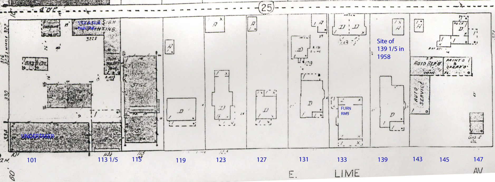
133 E. Lime Avenue
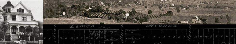
Town of Monrovia
Lot 21, Block B in the Town of Monrovia Subdivision lay unimproved until 1908 when Byron Clark built a two-storey house that would be a boarding house that provided furnished rooms for renters. The structure kept its function asa boarding house until it was torn down in the late 1950s.
The Sanborn maps show a two-storey, rectangular structure which is very common for commercial structures of that time. It was wood frame and had enough rooms to rent to ten people.
By 1921, Margaret Clark had died, and her husband moved to Anaheim to live with one of his daughters. They sold the business and the property, and the boarding house became the Ak-Sar-Ben Rooms in 1924. The owners then added a small dwelling at the back of the property by the alley with an address of 133 1/2 E. Lime Avenue.
This map shows the house on Lot 20, 131 E. Lime Avenue

This photo was taken during the 1960s. At this time, the four houses that were on these lots have been torn down and replaced by the utility building and a parking lot.
This map shows the house on Lot 20, 131 E. Lime Avenue
131 E. Lime Ave,
Town of Monrovia
James Elam Hunter purchased Lot 20 in 1888. The size of the Lot was 50 x 100 feet and backed on to an alley. No value was given in 1888, but in 1889, it was valued at $150. Tax records show the property bouncing among Hunter, J.E. Coffin (a merchant from Whittier) and Sherman Smith, losing value steadily, until Anna Kate Collins bought it in 1904 and built a house valued at $850 on it.
However, the permit records at City Hall show two permits for July 1921, one for a house and another for a garage. The contractors are Book & Anderson. Adding to the confusion is the 1920 census record, which shows Kate Collins and her daughter living at a house at 131 N. Myrtle Avenue. Possibly Kate had major changes done in the 1904 house and that accounts for the permits in 1921.
As can be seen by the Sanborn map, the house had a small front porch, a back porch for doing laundry, and a small bay window on the east side of the house. It is likely that the house had three bedrooms as the 1920 census, there are three people living in the house: a boarder, Kate Collins, and her daughter Catherine.
In 1921 there are two permits, one for a house and another for a garage. The second house is very small and has the address of 131 1/2. The one-car garage is at northeast corner of the property next to the alley.
There is no demolition permit, but it is likely the house came down in the early 1950s when other houses on the block were torn down for a parking lot.
123 N. Myrtle Avenue

201 & 203 E. Lime Avenue
342 S. Myrtle Avenue
For information on this property, see the entry for 334 S. Myrtle Avenue.

This map shows Lots 19 & 20 as a double lot, but Newlan's house is on the east side of the lot that will become 225 E. Lime Avenue

The map shows that Lots 19 & 20 have now been divided, and small second house has been added to Lot 19. The address for the back house is 225 1/2 E. Lime Avenue.

Where this parking lot is now, families lived out their lives, planted their gardens, and each played a part in the growth of Monrovia. This parking lot is rarely used.
This map shows Lots 19 & 20 as a double lot, but Newlan's house is on the east side of the lot that will become 225 E. Lime Avenue
225-225 1/2 E. Lime Avenue
Town of Monrovia
Levi Jackson Newlan owned this property from 1888 until 1907. He built a house, valued at $300 on the property in 1888 and lived in it with his two sons.
The Sanborn maps show the house as being a small structure with a front porch and a bay window facing east. Given the period of time in which it was built and the other houses built at the same time which still stand, it is likely that the house was a wood frame structure with modest Victorian architectural features. There are no permits for the house and the Sanborn maps show little change in the house.
Levi and his son Charles A. were blacksmiths, and his other son, Eugene Frank, was a harness maker. According to records, Eugene Frank did not stay in Monrovia very long, so the house was occupied by just the two others until Levi Jackson Newlan's death in 1906. After 1907, his Charles sold the property to B.A.P. Eaton, a retiree, who only owned his for two years, selling it to David S. West in 1910.
David West lived less than a block away at 127 E. Lime Avenue, and he rented out his new property over the years to many people. Sometime after 1927, an additional dwelling was built on the lot with the address of 225 1/2. Since there are no permits, it is difficult to determine exactly when it went up. However, there is a 1939 Monrovia directory entry for someone living at 225 1/2 E. Lime Avenue, so the second dwelling went up sometime between 1928 and 1939.
There is no demolition permit for this property, but it was probably razed in the late 1950s or early 1960s when the houses on Lots 17-20 were torn down for a parking lot to serve the utility company in the next block.

This map shows the intersection of South Myrtle and East Lime. The Renaker Mortuary hasn't been built on Llot 15, but other houses can be seen on Lime Avenue

The mortuary, built in 1911, fronts Myrtle, but there are entrances around the right hand corner on Lime Avenue.

After the mortuary was torn down, the lot went through several reincarnations as different types of businesses.
This map shows the intersection of South Myrtle and East Lime. The Renaker Mortuary hasn't been built on Llot 15, but other houses can be seen on Lime Avenue
334 S. Myrtle Avenue
Town of Monrovia
Though James J. McLachlan was the first owner of the property, but he didn't actually own it until 1889. In the 1888 tax records, the owner of this lot is unknown, but the value of the land reflects its prime position as a corner lot on the northeast corner of South Myrtle and East Lime Avenues. It is assessed at $800, and the value after equalization is $300. The tax assessor’s book has no tax listed, but indicates the property has sold, but not to whom. The 1889 tax records show Lot 15 (as well as 13 and 14) belonging to James McLachlan. The lot’s value has dropped to $600, reflecting the bursting of the land boom bubble. The taxes due on the property are $3.90, but the property is sold to H. Hart.
The earliest subdivision map shows the following. The lots on the north, east, and south sides of Block B (the 100 block of East Palm, the 200 block of South Ivy and the 100 block of East Lime) all have north-south orientation. The dimensions are 50 by 140 feet deep. The back of each lot ends at the alley that bisects the block horizontally, east/west.
However, lots 10-15 were divided so that they fronted on South Myrtle. Their dimensions are 53 ⅓ by 150 feet. The Sanborn maps show no structure on Lot 15 until 1913, and that structure is the Renaker Funeral Parlor. It is unclear from the maps and directories what direction the front of this building faced when it was first built in 1911 because Sanborn maps indicate there were entrances with addresses into the building from the Lime side of the mortuary.
The first structure was owned by Charles Taylor (known as C.T.) Renaker. In 1887-88, his father, James John Renaker, had a funeral home/furniture/stationery store first in the Badeau Block, at the southeast corner of Colorado and Myrtle and then at 627 S. Myrtle. J.J. Renaker died in 1904, around the time the funeral parlor burned down, and C.T. constructed a new building for the mortuary business, including an apartment on the second floor for himself, his mother, and his brother Leslie.
For decades, the address for the funeral home was given only as the corner of Lime and Myrtle. It wasn't until 1926 that the city directories began to list an address, 334 S. Myrtle Ave., for the Renaker Funeral Parlor. Specifically, the following addresses are all associated with the structure the Renakers owned on Lot 15.
101 E. Lime
103 1/2 E. Lime (likely Mrs. J.J. Renaker's address as she lived upstairs over the mortuary)
107 E. Lime Ave.
109 E. Lime Ave.
111 E. Lime Ave.
342 S. Myrtle Ave.
By the late 1930's, the address for the mortuary is 334 S. Myrtle and Lot 15 still has that address today.
The first permit for this building is in 1914 for a sewer, but the permit is issued to to the 111 E. Lime address of the building. Another plumbing permit was issued in 1927 for the same address. It is most likely that this entrance was for the bodies and where cadaver preparation was done, so the plumbing would need to located at that interest.
There is no permit for demolition, but there is a construction permit indicating Lot 15 has been combined with Lot 14 to make a dress store, an Anita Shop, a chain of dress stores which existed through the 1950's and early 1960's.
Since 1957, the structure has had numerous owners and morphed through numerous businesses/

This picture was taken shortly after the house was built...around 1888.

This picture was taken shortly after the house was built...around 1888.
125 N. Myrtle Avenue
Monroe Addition
The north 70 feet of Lot 8 was purchased by John J. Renaker in 1889 from the owner of the Monroe Subdivision, William N. Monroe. At the time, the land was valued at $150 and the house he had built on it was valued at $800. John Renaker ran a mortuary with his two sons, Charles Taylor and Leslie Morton, and his wife Elizabeth Stewart Renaker. The sons lived in the house until they married,. John Renaker died in 1904, and Elizabeth continued to live at 125 N. Myrtle until continued to live in the house until around 1926 when she moved into the apartment above her family's mortuary on the northeast corner of South Myrtle and East Lime Avenues.
This map shows the very simple, modest house that Adeline F. Wright built.
Adeline Wright's house has the address of 127 E. Lime Avenue.

This map shows the very simple, modest house that Adeline F. Wright built.
127 E. Lime Avenue
Town of Monrovia
Lot 19 was undeveloped until 1898 when Adeline Wright built a small house. Sanborn maps indicate the house was made of wood. The style of the house would have been a plain Victorian with little ornamentation. The map shows the house to be small
There are no permits for the property, so it is unknown if there were alterations to it. There is no record of when the house was torn down, but it probably was razed around 1953 when the house to the west at 123 E. Lime was demolished for the California Water and Telephone Company and its parking lot.

The Edwin P. Large house is the next to the two storey house onthe corner of Myrtle and waht was then White Oak Avenue.

The Edwin P. Large house is the next to the two storey house onthe corner of Myrtle and waht was then White Oak Avenue.
121 N. Myrtle Avenue
Monroe Addition
The tax records for 1888 list Edwin P. Large as the first owner of Lot 9, Block C. At that time, the value of the land is $300 and there is no improvement on the property. Tax records for 1889-1892 are missing, and the tax tax record for 1893 shows the value of the property still at $300 but a house, valued at $900, has been added.
The tax records here are misleading as a panorama photo of the area in 1887 shows a house on the property. Property was changing hands so quickly that city clerks often loss track of who owned a property and/or whether or not there was an improvement. However, besides the panorama view, the May 28, 1887, edition of the Monrovia Planet states that architects and builders, Messrs. Zimmerman and Blair have plans...for a residence for E.P. Large at a cost of $3,000. The "Blair" referred to is Luther Reed Blair, the architect of several other Victorian houses in Monrovia, one of which is still standing.
From 1895-1899, he house is owned by Lettie A. Forbes and increases in value to $1,000, but in 1900, Edwin P. Large owns the property again, but now house is gone. The tax information for 1901-1904 is missing.
On Lot 17 can be seen the very simple house Dr. John T. Stewart built.

At this time, Dr. John T. Stewart still owns the property, but his brother-in-law John Renaker is renting it as a furniture store.

On Lot 17 can be seen the very simple house Dr. John T. Stewart built.
119 E. Lime Avenue
Town of Monrovia
Lot 17 stayed empty until 1907, when John T. Renaker built a small, rectangular-shaped house. He never intended to live in it as he was a member of the Renaker family that owned a mortuary just down the block from Lot 17. Death being a regular occurance in any community, the Renakers stayed busy. For a period of time, they also had a furniture store.
In 1907, the house was valued at $500. Though the property increased in value, the house did not. In 1913, there is a permit taken out by Renaker to hook the structure up to a sewer. Renaker rented out the house to different business owners who ran their businesses from the house.
In 1908, the building was used by Arthur Pomeroy for his real estate business. Later in 1913, Leslie Renaker (brother of John T) had a furniture store there.
There is no demolition request for this house, but it was probably torn down in 1954 when the house to the west, 115 E. Lime Avenue, was torn down so that the California Water and Telephone Company could be built.