
123 E. Lime Ave.
KNOWN DETAILS

This is the office for the Venderink Improvement Company when it was still on Myrtle Avenue. It was then moved around the corner to Lot 18, 123 E. Lime Avenue. Later, it was modified into a house.

Lot 18 is the third vertical lot from the left on the north side of lime. It has been enlarged from the office it was: a porch has been added, but "bump out" window can still be seen on the right side of the building.

The houses which had been at this location were torn door, starting in the 1950s, for parking. The brick building at the left is the Verizon Communicaitons building.
This is the office for the Venderink Improvement Company when it was still on Myrtle Avenue. It was then moved around the corner to Lot 18, 123 E. Lime Avenue. Later, it was modified into a house.
Description
The the first owner is listed as Joseph Sartori, but actually the tax records don't list him as owner until 1891. This property had a rough beginning, bouncing around from owner to owner as the value of property in Southern California plummeted after the land boom of 1888. It is unknown who owned Lot 18 from 1888 until 1891. Lots were changing hands quickly as speculators came to communities like Monrovia buying property to flip quickly for a profit. Many times buyers flipped properties by bills of sale because they hadn’t had time to record the ownership with the County. The land boom was over quickly, and buyers went broke when they couldn’t unload their property, so rather than pay taxes on property that had dropped over 37 percent, many buyers just walked away. By 1890, Lot 18's assessed valued had dropped from $600 to $200.
The tax record for 1891 gives Joseph Sartori, a successful banker, as the owner. In 1891, the property’s value had dropped to $125. Sartori sold the property to Charles E. Slosson, who was in real estate, and held on to it until 1903. By then, the property value had been valued at $75 for the last six of the eleven years he owned it, so he must have gotten tired of waiting for property values in Monrovia to go up. Subsequent owners were in and out quickly: G.H. Smith owned it for one year, selling to it to C.F. Monroe who appears to have only owned it for year. However, it is this year, 1905, that the tax records record show an improvement on the property.
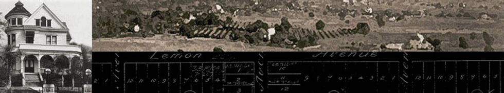
The value of the improvement is $600, indicating more than just a barn. It may have been at this time that the structure, which had been moved from another location, first appeared. According to Steve Baker, Monrovia City Historian, the house that appeared on Lot 18 in 1905 had actually been moved from Block G, Lot 13, on South Myrtle. At that location, is was a combination business and residence of the Venderink family. The name of the business was the Venderink Improvement Company, and it was involved in construction work. The Sanborn map and the illustration from the periodical The Wasp indicate that the structure was in existence at least by 1887.
In 1906, Monroe sells the property to Mary Bear, and the value of the structure goes up to $700. She may have gotten into a little financial trouble because the following year, there is a different owner, G.W. Morgan. Mary Bear owns it again the next year. The 1908-1909 Resident and Business Directory of Monrovia lists three women, Mary, Julia, and Alice Bear, as living at the address. I’ve been able to find no information about them.
In 1910, Mary Bear sells the property to F.W. Rogers. Mr. Rogers seems to have used the property as a rental. In the 1911, the Monrovia Resident and Business Directory shows that Thomas T. Davis, employment not stated, lived in the house with his two children: Charles Franklin and Helen J., both clerks at the post office. They only lived here for a short time. In the 1913-1914 directory, the Davis family, minus Thomas, is living at 134 N. Myrtle Ave. F.W. Rogers sells the property the next year to S. Emerson Salisbury, a dentist.
The Salisburys had been living at 337 N. Mayflower, and his dental practice was at 527½ S. Myrtle Avenue (1908 Monrovia Directory). He and his family moved to 123 E. Lime Avenue by 1913, but he moved his business to the American National Bank Building at the corner of South Myrtle and Lime Avenues. By 1924, Dr. Salisbury had moved his practice into his home. This was not unusual, and several doctors in Monrovia had their medical offices in their homes as it was a great way to cut overhead. The Salisburys lived on in the house until at least 1945 when Fanny Salisbury died. It is unknown at this time exactly when Dr. Salisbury died, but it was probably in the early 1930s.
The actual address of the dwelling, formerly the office/home of the Venderink family, first appears on this property as 123 E. Lime Avenue on the Sanborn map of 1907. The details from the Sanborn maps show that the footprint of the main house is exactly the same from 1888 to 1907. In 1897, a porch was added to the back of the house. In 1907, a front porch which wraps around the east side of the house can be seen. The 1913 Sanborn map shows a shed at the back of the property, which has been replaced by a small auto garage by 1923. The illustration shows the structure at its South Myrtle address around 1888. It has the typical Victorian front-facing gable design of the period. What can’t be seen in the illustration but is shown on the 1907 Sanborn map is that the bay window on the south side of the house is replicated on the north.
An application to alter, repair, or demolish was filed by the California Water & Telephone Co., located at 115 E. Lime, on April 2, 1952. The application requests permission to demolish a residence and a detached garage at 123 E. Lime Avenue. This house, along with others on Block B, was then demolished to build the California Water and Telephone Company and a parking lot for the utility's workers.